VFR Flight Guide Ireland 2011
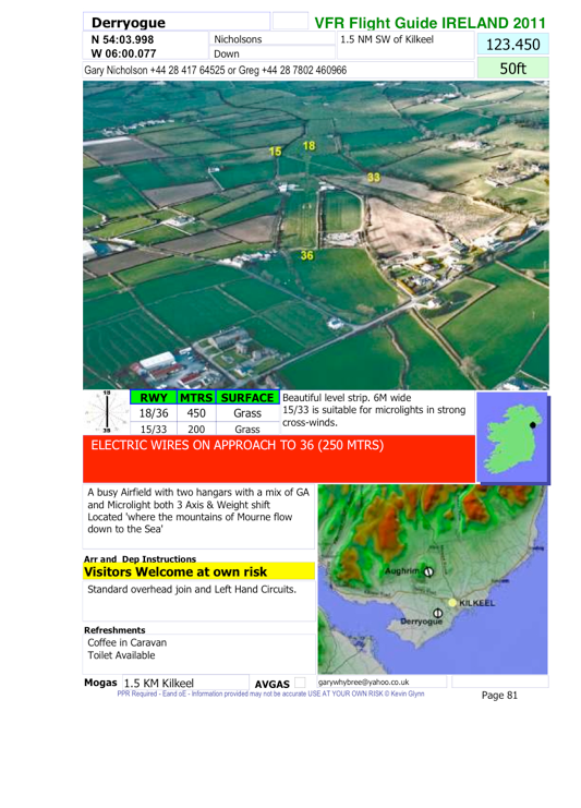
Airfield Plate - (example Derryogue)
We have considered carefully the design of the airfield plate and consulted with the many pilots who have used the previous book over the last five years.
Mostly, the comments were that we should avoid making any major changes as people had become familiar with and liked, the design. However, it was decided that the plate could be updated the add some additional features.
The information contained in the plate (L to R - Top to Bottom) is:
Example of a page from the flight guide.
Airfield Name,
ICAO Code,
Co-Ords,
Alternative Name,
Distance to nearest town,
Frequency,
Contact name & Telephone,
Elevation,
Picture,
Compass indicator,
Runway heading,
Runway Length,
Runway surface type,
Description of surface conditions,
Ireland Map (NEW),
Cautions,
Airfield description,
Area Map,
PPR requirements,
Refreshments,
Nearest reliable mogas,
Avgas,
Email,
Web site.
NOTES ON INFORMATION
Co-ordinates: In the form DD:MM.MMM
Distance to nearest town: To assist with locating the airfield.
Frequency: Not an assigned one - but try this freq. if overhead the airfield.
Elevation: Provided by the owner, use as a guide only.
Picture: Technical, and is fully explained here
Compass indicator: Just a little help near a busy airfiled.
Description of surface conditions: These are provided by the owner and may help during briefing.
Ireland Map (NEW): Location at a glance.
Cautions: Pay attention here, Confirm during briefing that they are correct and haven’t changed.
Airfield description: Knowing what is flying here can help with decision to use.
Area Map: This helps with locating the airfield using a ‘Geo-picture’ of the area.
PPR requirements: The conditions you can be accommodated within. ALL Airfields are PPR.
Refreshments: Cup of Tea ? - Maybe even a biscuit !
Nearest reliable mogas: Where does the owner usually go for Mogas
Avgas: YES/NO
REMEMBER: PPR is GOOD AIRMANSHIP - ALL airfields are at your own risk.